Two radios on one mast, and the question each one answers
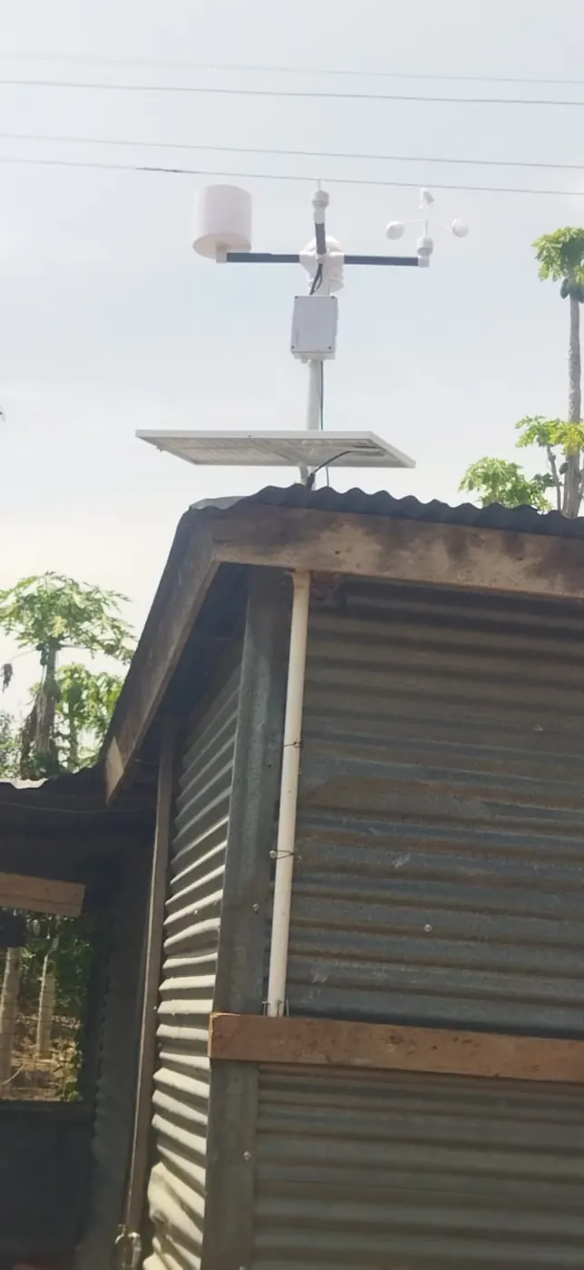
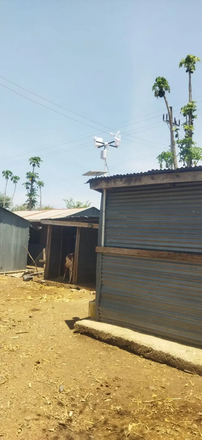
A LoRaWAN weather station on a Kenyan farm runs two radios, so asking 'how far does it reach' leaves you unsure which one is meant. The first radio only listens. Soil probes buried across the blocks send their readings in over LoRaWAN, which the FAO's report on digital revitalisation of agriculture in the Mashreq spells out as Long Range Wide Area Network, and the station on the mast is what they send to. The second radio talks outward. It carries everything the station heard, plus its own air temperature, humidity, pressure, sunlight, rainfall, wind speed, gust and direction, to the internet over a Safaricom SIM card, or over Wi-Fi where the farmhouse has it. Only that first link has anything to do with farm geography. Whether Safaricom reaches the mast, your phone will answer, standing next to it.
This piece takes the first link apart, from the moment a probe wakes to the moment its number lands on your phone, and gives the figure that governs each step wherever a source supplies one. One warning before we start: no source here puts a LoRaWAN range in kilometres for a Kenyan farm, and none will be invented. Even the World Bank's review of technological options for agriculture lists LoRaWAN among similar networks without offering a range figure. A number printed on a vendor's box is a best case, measured somewhere flat. Your block is the test.
The reading starts in the soil, roughly every ten minutes
Each soil sensor carries a shallow probe and a deeper one, and each depth reports a moisture channel and a soil temperature channel. Moisture comes in as percent of sensor scale, where 60 to 85 counts as normal. Across 15 NuaSense probes between 09 October and 08 November 2026 the pooled average sat at 67 percent of scale, with most readings between 39 and 86. That is a sensor-scale figure, not volumetric water content, and the radio does not care either way. It carries a small packet holding those four channels roughly every ten minutes.
Ten minutes governs this step and the diagnosis at the end. A link that works gives you six packets an hour, hour after hour. Over the same month the station end produced 26,987 ten-minute readings across the network, which is what a healthy cadence looks like in bulk. Any gap in that rhythm is either a packet that never arrived or a probe that never sent. Know the link and you can say which.
In shape this is the low-cost LoRa smart irrigation system described on AGRIS: nodes spread across the field to watch the soil, a full weather station for climate data, and a remote server that stores both and works out Penman-Monteith reference evapotranspiration daily. That trial gave low investment cost and high energy autonomy as its reasons for suiting off-grid areas with limited water. A NuaSense station computes ET0 hourly and never touches the pump, but the chain is the same: probe measures, station relays, server does the arithmetic. Only the radio hop depends on where you stand.
Line of sight comes first
Radio between a probe and a mast acts more like light than sound. A signal that can see where it is going arrives strongest. One that has to push through a brick store, a water tank, a banana stand or a shoulder of ground arrives weaker, and somewhere along the way weaker turns into nothing. Vendors publish a range measured with both antennas in the open, usually on level ground, and nothing in the source list measured anything else. Whatever range you get quoted was almost certainly a clear-sky, clear-ground figure.
So the first check is the oldest one in surveying. Stand where the probe will go, at the height its antenna will really sit, and look toward the mast. If you cannot see the mounting point, the radio is pushing through whatever blocks your eye. On a Kenyan smallholding that blocker is rarely dramatic: a stone wall round the homestead, the cowshed, a mabati store, a line of grevillea planted as a windbreak, napier grass along a terrace edge. Any of those standing between probe and mast is a loss you chose.
Siting for weather and siting for radio usually come down to one decision. The Arizona extension service's grower's guide on weather stations reports field visits that found stations sitting too close to buildings or under trees, and sensors at non-standard heights, and it says plainly that improper installation can produce data leading to poor management decisions. Those faults were recorded for the weather instruments, not the radio. Still, a spot that gives a rain gauge clean exposure is almost always a spot with a clear view, and a clear view is what the LoRaWAN receiver wants too.
Ten times the height of whatever is in the way
Arizona hands you a single figure for obstacles: set the station about ten times the height of whatever might shade or shelter it. A shed three metres tall wants the mast thirty metres away. A tree line twice that height pushes it sixty metres out. That multiplication is the whole rule. It was written for wind, rain and temperature exposure, not for radio. Keep those two things apart.
The same rule still does double duty. An obstacle close to the mast shelters the anemometer and shades the gauge. That same obstacle also sits between the receiver and whichever probes lie beyond it. Pace out ten times the height of the nearest building before the mast goes up. That gives the cups the open fetch a wind sensor needs and moves the receiving antenna out of the radio shadow of the biggest thing on the compound.
What the rule cannot do is tell you how much signal a given obstacle removes. No source quantifies penetration through a wall, a canopy or a ridge. Treat the ten-times distance as a floor for the mast's clearance from the homestead, not as a radio specification. If the only place that satisfies it is the far corner of the farm, the probes nearest the house will be looking at the mast across the very buildings you stepped away from. Height is the lever that eases both problems at once.
Mast height is the lever you actually control
Every metre the station rises lifts the receiving antenna above walls, crops and the gentle swell that a flat-looking block always has. It does that for every probe at once. A probe antenna sits where the probe sits, low and surrounded by the crop it measures. You cannot raise it without moving it off the soil you want to read. So the mast carries the whole burden of line of sight.
No source in the bank gives a mast height for radio. What the weather.gov siting guidance for personal weather stations adds is a figure about how the mast is built, not how tall it is: a rain gauge mounted on a 2-inch diameter pole should sit on a boom extending 6 inches out from the pole, so the pole does not shelter the funnel. Carry that sense over to the antenna. Anything mounted hard against the pole, or tucked behind the solar panel, is partly shadowed by its own mast. A shadow at the receiving end costs every probe on the farm.
For a Kenyan buyer the trade is concrete. A taller mast means more steel, more guy wire and a harder climb for whoever cleans the gauge after a dust storm. A shorter one is cheaper, safer and hears fewer probes. The station is solar powered, so nothing ties it to the house. Placement and height are yours alone. Fix the position by the ten-times rule first. Then raise the mast only as far as the furthest probe needs, checked by the look-along-the-line test probe by probe before the concrete sets. Height bought afterwards is expensive. Height planned is a longer pole.
Hills, terraces, and the canopy that grows after the test
Flat ground is the easy case. Most Kenyan farms are not on it. A terraced hillside in the central highlands, an irrigated strip along a river on the plains and a coastal shamba each put the ground itself between probe and mast in a different way. The sources measured none of them. What follows is geometry, not a trial, and should be read that way.
A ridge between two antennas is a wall made of soil. Terraces stepping down a slope put each lower probe behind the lip of the terrace above when viewed from below. The same probes are in clear view when the mast stands above them. On a hillside, then, the mast wants the top of the block, not the house at the bottom, even when the house is where the Wi-Fi is. A valley block with the homestead on one shoulder may find that probes on the far slope see the mast perfectly while a probe on the valley floor, closer in metres, sees nothing but the near bank. Walk the line for every probe before any hole is dug. Accept that one probe on a steep site may need to sit where it can transmit from rather than the agronomically perfect spot. Write that compromise in the installation notes. A probe reporting from a slightly compromised position beats one that measures perfectly and is never heard.
Then the crop grows. A link that worked in a freshly planted block has to push through a wall of leaves once the canopy closes. Maize at tasselling, a banana stand, sugarcane, napier along the boundary, all rise above a probe's antenna. Vegetation holds water too, and the network's own record shows how much wet there is to hold. Across 15 NuaSense stations from 09 October to 08 November 2026, relative humidity averaged 72 percent and reached 100. 30 percent of station-hours were recorded as leaf-wet, about 7.1 hours in an average day. Wet foliage is a worse place for a radio than a dry field. No source measured by how much on a Kenyan maize block. So the test at planting is not the test that counts. Check the link when the canopy is tallest and the season wettest, and let mast height pass at that stage. A probe that goes quiet only in the weeks the crop stands at full height points to a canopy problem. The fix is usually the mast, because the probe cannot leave the crop.
Storms hit the station end as well. The gust channel records what the mast took. It is a peak within each ten-minute interval, not an instantaneous reading. If a mast leans after a storm, its antenna has moved. Probes that were marginal before can go silent after. Read the gust record to know which days to go and check.
From the mast to the internet: the hop that is not LoRaWAN
Once the station has a probe's packet, LoRaWAN has done its job. The next step is ordinary mobile data. The station sends its own readings and the probes' readings to the server over a Safaricom SIM, or over Wi-Fi where the site has it. On the SIM, the data fee is passed on at cost, typically about one US dollar per station per month. On Wi-Fi there is nothing to pay. The AGRIS LoRa paper describes this hop as the weather station connecting through a gateway, so climatic and soil data are stored regularly on a remote server. In a NuaSense layout, the station on the mast is that gateway. There is no separate box to buy.
So the second range test is one every Kenyan already knows. Stand at the mast site with a Safaricom phone. If data works there, the station will reach the server. If it does not, the options are Wi-Fi from the house, a different mast site, or no station. Wi-Fi pulls the mast toward the buildings the ten-times rule pushed it away from. None of those is a LoRaWAN problem. Confusing the two is how a buyer ends up blaming the probes for a SIM with no signal.
A Kenyan design makes the same split from the other direction. In the National Research Fund repository paper on an IoT mini weather station for machine learning, humidity, temperature, light intensity and atmospheric pressure are measured on site. They are sent to a cloud server to feed forecasting and advisory models. The authors note that most farmers in Kenya practise small-scale farming and struggle to get timely, accurate weather information. What is measured is measured on the farm. What is inferred is inferred later, elsewhere. A LoRaWAN link only ever carries the first kind, and that is the kind this site reports.
Three distances that are not the radio range
Three distances get quoted around farm weather data in Kenya, and none of them is a LoRaWAN range.
Smallest is the SMS radius. The PlantVillage account of precision advice on feature phones says iShamba sends weather forecast SMS based on geo-location within a radius of 5 to 9 km. Sending 350,000 messages a week costs 1,800 US dollars. Everyone inside the circle gets the same message. Those are the economics of broadcasting. A NuaSense alert by SMS or WhatsApp costs 0.03 US dollars per message, so 350,000 of them would come to 10,500 dollars. That gap is the difference between one forecast for a district and one measured alert per farm.
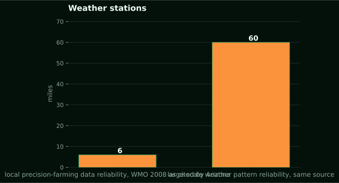
In the middle is the 6-mile rule. Arizona cites WMO guidance from 2008: weather data are most reliable for local precision-farming use within about 6 miles, and for large-scale patterns within about 60 miles. Six miles answers whether a measured reading from somewhere else describes your field. It is a representativeness distance, not a radio range, and this site will not let it be read as one. Sixty miles is pattern, the Kenya Meteorological Department's job. A LoRaWAN link lives inside the farm boundary. That is a fourth and much smaller scale that none of these touches.
Why the station across the county reads a different sky
Arizona ran the representativeness test with humidity. A Li710 sensor recorded relative humidity in a grower's field at Gila Bend from 12 to 19 February 2025. The comparison was against AZMet stations at Paloma, 15 miles off, Buckeye at 27 miles and Harquahala at 41 miles. AZMet is 32 well-maintained stations concentrated in the agricultural south and west of the state. That is denser coverage than most Kenyan growers can reach. Still, the guide's preliminary finding was that an on-farm station could improve reference evapotranspiration for site-specific management. Humidity feeds ET0, and a difference caused by distance, or by whether the distant station sits in a just-irrigated block, moves the irrigation number.
Now the transfer. A Kenyan farm is usually more than 15 miles from any station it can get data from. That station is not run like its own block. In the NuaSense network, from 09 October to 08 November 2026, rainfall totals per station ranged from 0.0 mm to 122.8 mm across 14 stations in the same month. The stations are not co-located. The spread is between them, not a regional figure. Even so, it says a rain total borrowed from elsewhere in the country can be wrong by the whole of a month's rain. That is the case for a station on the mast. It is a measurement argument, independent of the radio. The earlier post on how accurate a farm weather station is, sensor by sensor goes through what each channel can resolve once the reading is in. This one stops at getting it there.
What it costs, and who should keep the money
A NuaSense weather station costs KES 30,000 excluding taxes. It is the mast end of everything above: air temperature, humidity, pressure, sunlight, rainfall in millimetres by tipping bucket, wind speed, gusts and direction. It is also the LoRaWAN receiver the probes report to. A soil sensor costs KES 7,000. The two-moisture, two-temperature variant is KES 9,000, and one that also measures EC is KES 10,000, though EC is not yet streaming from the deployed fleet. Dashboard use is free with five direct downloads a day. API access is one US dollar per 1,000 calls. Payment falls due a month after the station is installed and transmitting. A full money-back guarantee runs for three months, and a six-month warranty covers damage the customer did not cause.
Who should keep the money. A grower with one block, walked every morning, who mainly wants to know whether it rained, is better served by a plastic gauge and a notebook. The post on which sensors a farm needs makes that case. NuaSense's own post on IoT applications in Kenyan agriculture runs through low-cost sensor technologies smallholders can afford and mobile platforms built on phone penetration. It is honest that the cheapest tool is often the right one. If a farm's only mast site has no Safaricom signal and no Wi-Fi, do not buy until that is solved. On a steep, broken site where the line-of-sight walk fails for most probe positions, buy the station and one probe. Prove the link at full canopy, then buy the rest. That is what the three-month guarantee is for.
On regulation, the Communications Authority of Kenya governs radio spectrum in the country. No source here says what it asks of a farm LoRaWAN installation, if anything. Ask the Authority directly. Do not take a vendor's word, this one included. A station on our weather data page is sold as hardware and the service around it, never as data.
When the readings stop: lost packet, dead probe, silent mast
No source in this article answers how to tell a lost reading from a dead sensor. The AGRIS trial reports that its nodes ran. It does not describe diagnosing a silent one. Arizona covers bad siting, not dead radios. What follows comes from how the chain is built. Treat it as a way to think, not a tested procedure. It is also the part a vendor is least likely to write down.
Three places can break. Each leaves a different hole in the record. Suppose the station's own ten-minute readings keep coming and one probe stops. The fault sits on the probe side of the link: the probe, its power, or the path to the mast. Did it go quiet when the crop reached full height? Check the path before the probe. Did it go quiet after a day with a high gust reading? Inspect the mast first. Readings that arrive in a broken rhythm, with some packets through and some not, mean a marginal link. It will get worse as the canopy rises. If every probe and the station fall silent together, the probes are almost certainly fine. The station or its SIM is the problem. Walk to the mast with a phone.
Failures that produce readings instead of gaps are worse. A station under a tree reports rain and wind faithfully for a spot that is not your field. Arizona's field visits found exactly that. Stations sat too close to buildings, under trees, at non-standard heights, and out of the recommended distance from the crop. Each produced data that can lead to poor decisions. A link that reaches perfectly from a badly sited mast delivers the wrong numbers on time, every ten minutes. Range is the first thing to get right. It is a long way from the last.